Posted tagged ‘Lake Superior’

Junior Bears’ Big Weekend Road Trip

April 26, 2015

Weekend Road Trip

1.  Blind River

Frozen Lake Huron.

Bear Lake Huron

They have this stupid windmill located on the lake shore.  Of all the times we’ve been here, not once, have we ever seen it working.   Ever.

Bear Stupid Windmill

2.  Katherine Cove

Frozen Lake Superior.  Junior sees two Great Lakes in one day.

Bear Catherine Cove

A Mom with her kids was on the beach.   Her five year old son wanted a photo of his toy with Junior.  It was some kind of dragon that spat our a plastic flame, from a McDonalds Happy Meal.

I asked the kid what the toys’ name was.  He said it didn’t have one.

I suggested “Clem”, but the kid shook his head “No”.

Then I suggested THUN-DAR and he agreed.

So here is Junior with THUN-DAR.

Bear Thundar

3.  Old Woman Bay

This is last view of the lake you get from the highway, until you get to Marathon, another 200 km further down the road.

Bear Old Womans Bay

4.   Pebble Beach, Marathon

Of course there’s a sign telling you not take any rocks with you.

Bear Marathon Ontario

History

5.  Rossport

There is absolutely nothing here except some houses     Not even so much as a convenience store.

Bear Rossport

Bear Rossport alke

6   Thunder Bay

This was the furthest west we could reasonably go for the weekend, and still get back to work on time for Monday

Bear Thunder Bay

It was the first town with traffic lights since we left Sault St. Marie.

Bear Traffic Lghts

7. Terry Fox Memorial, Thunder Bay

He ran the equivalent of a Marathon every day, from St. Johns Newfoundland to here.

Bear Terry Fox

8  Beardmore

This is the only thing the town had going for it:  a giant snowman.

Junior was pleased that he was sitting in the “BEAR” letters”.

Bear Beadmore

9.  Geraldton

Sunday morning, at 11:00 AM.

This was one of the “bigger” towns in the area.  So we tried to find a single restaurant that was open.   With no success.

Where do people here go to eat?   There wasn’t even a truck stop.

Bear Geraldton

Bear Geraldton Downtown

10.  Hearst

Big Critters.  Junior made some friends.

Bear Hearst

Junior Moose

Since Thunder Bay, this was the longest stretch of paved road (500 km) we have ever seen without a single McDonalds or Tim Hortons.

500 km mcds

There was also the biggest log pile we have  ever seen.

Bear Log PileBear Log Pile 2

11.  Moonbeam

Everything is always better, when you got UFO’s.

Bear Moonbeam

12.  Giant Polar Bear 

In downtown Cochrane.

Please note:  DO NOT CLIMB.

Bear Cochrane

13.  49th  Parallel

This is just about the saddest road-side attraction I have ever seen.

Beaer 49th Parallel

Bear Plaque

14    Giant Bison

His name is apparently “Earl”.    Maybe being next to Earlton has something to do with it.

Bear Earl the Buffolo

All in all, we drove more ~ 2700 km.

If this had been the UK, we’d have driven a big chunk of the entire country.

Driving UK

Different Faces of Superior on a Rainy Long Weekend.

May 25, 2013

Superior Faces

a

1.   Keweenaw Bay

Saturday, just north of L’Anse.   Kind of a miserable day.

Lake 01 South of L'anse

a

2.  Copper Harbor

Sunday morning.   That’s the ferry to Isle Royale, though I”m not sure if it was running yet.

Lake 1 Copper Harbora

3.  Copper Harbor 

Fishermen going after splake.

The day was calm, but you could hear thunder coming from the dark clouds on the far horizon, so low in frequency as to barely be audible.

It was very ominous.

Lake 2 Copper Harbor

a

4.   Near Eagle Harbor

Just ~ 10 miles down the road from the fishermen.

Lake Eagle Harbora

5.  Near Eagle Harbor

Lake 4 Eagle Harbor

a

6.  Bete Grise

Cold and damp…it was 48F.   But an hour later, just 40 km to the south at the town of Laurium, it was in the mid 70’s.

Lake 5 Bete Grise

a

7.   Between Marquette and Munsiing

Later that same day.  It was warm, sunny and calm, almost summer-like.

It was a totally different lake.

Lake 6 Munising

a

8.  Twelve Mile Beach (Picture Rocks National Lakeshore)

The next day (Monday).

Needless to say, this was off-peak tourist season, and I had the entire place to myself.

A storm was building on the horizon again, and the water had a greenish grey hue.

Lake 7 Twelve Mile

a

9.  Twelve Mile Beach

Lake 8a TwelveMile

Exact same location, just facing East instead of West.

It’s amazing how much the lake can change, even just by turning around 180 degrees.

a

10. Grand Marais

A small beach town on the lake, though nobody was really there this time of year.

I didn’t get out of the car much.   The storm had caught up with me and it was a torrential downpour.

Lake 9 Grand Marais

a

11.  Whitefish Point

Later Monday afternoon.  Close to where the wreck of the Edmund Fitzgerald happened.

This view is from the lighthouse.

Lake 10 Whitefish Point

a

12.  Whitefish Point

Facing West…with yet another storm building on the horizon.

Lake 11 Whitefish Pont

a

13. Near Paradiseer

Lake 12 East Shore

Facing east, just south of the town of Paradise.

Though it didn’t feel like paradise that day.

Superior was being a real witch, and the storm system followed my for 500 km on my drive home.

a

My Best Photos Of The Month For 2012

January 12, 2013

January (Ottawa River, Eastern Ontario)

2012-01a

February (Silverstar, B.C.)

2012-02a

March (Revelstoke, B.C.)

2012-03a

April (Algonquin Park)

2012-04


a

May (Happy Duck-Toller)

2012-05 - Copy


a

June (Junior Bear, Lake Winnipeg)

2012-06 - Copya

July (Lake Superior, Neys Provincial Park)

2012-07 - Copy


August (Sec Lake, Algonquin Park)

2012-08


a

September (Eastern Ontario)

2012-09


a

October (Eastern Ontario)

2012-10a

November (near Wakefield, Quebec)

2012-11


a

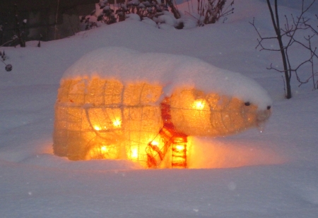
December (Christmas Polar Bear, my front yard)

2012-12

a

a


This is why I hate watercolors.

October 29, 2012

Just finished off a painting tonight of Neys Provincial Park (on the North Shore of Lake Superior).   I spent a lot of careful time on this.

I was feeling reasonably happy with this my work, until it was time to go home, and I noticed a bright blue smudge on the left.

God Dammit.

Some blue pigment from one of my tubes tube had inadvertently gotten onto the paper.

I tried lifting it, but it was too late.    The damage was done.

Well, at least the stain wasn’t smack in the middle of the painting, or two entire evenings would have been completely written off.

But if I crop off 1/2 an inch,  the painting is still salvageable.  I got off lucky this time.

But still…it’s not quite the same.   I”m bothered by this.

This is why I HATE watercolors sometimes.

It’s so damned unforgiving.

a

Junior Bear Rates Some of the Beaches of Lake Superior

August 11, 2012

a

1.  Agawa Beach, Ontario.

Located in Lake Superior Provincial Park, right off Highway 17.  Nice long sandy/pebbly beach.  Not too crowded, even in peak season.

If you go there after Labor day it’s pretty much empty.

The water is cold early in the season, but it’s shallow and warms up nicely.   Towards the end of August, I find it’s  one of the nicest swimming beaches on the lake.

Junior Bear’s Rating:  9 out of 10

a

2.   Gargantua Beach, Ontario. 

To get here, you have to exit Highway 17 and drive on a gravel road for 15 km through the bush.

This is one of my favorite quiet areas, away from the crowds.  It gives you a good sense of remote wilderness.   Even in peak season, you might be lucky to see a couple of other hikers or kayakers here, and that’s it.

The beach is very rocky with big round pebbles, and not really good for swimming, though.   The water is deep and cold.  It almost looks too dangerous to go into the water here.

Junior Bear’s Rating:   7.5  out of 10  (due to lack of swimmability)

a

3.  Old Womans’ Bay, Ontario.

Nice little cove, with sheer cliffs and sandy beach, just south of Wawa.   Sea kayakers enjoy this area.

I always stop here because it’s right off the highway and it’s a quick photo op.    The water is deep and cold, though.   I once dunked my head here in May, but I don’t usually swim here.

Junior Bear’s Rating:   7 out of 10 (due to poor swimmability and close proximity to the highway).

a

4.   Sandy Beach, Ontario.

Located a few km off Highway 17,  just outside of Michipicoten.

This is one of my favorite beaches.   It’s sandy and quiet.   Even on a summer long weekend, you can have the place almost all to yourself.   It’s a great place to come in the evening and relax and just listen to the lake.  This is where I get my “Zen Like” moments.

This is a special part of Lake Superior.   Just west of this beach is a long tract of roadless wilderness.  For about ~ 150 km there’s nothing but pristine shoreline with no towns or cottages or road access.  It happens to be the  longest undeveloped freshwater shoreline in the world.   This is what’s so special about Superior, compared to the other crowded Great Lakes further south.

The water is cold and gets deep quickly.  I don’t bother swimming in June or July, but towards the end of August you can probably brave the water.

Junior Bear’s Rating:  10 out of 10

a

5. Pebble Beach, Ontario. 

This beach is found just outside of Marathon, Ontario, which is a pulp and paper town on the  north shore.

This is definitely NOT a swimming beach.   It’s strewn with football-sized pebbles and piled high with driftwood logs.

You can hardly walk on the beach without risking a sprained ankle.  The water is very cold, and  gets deep very quickly.   Again, this looks like it would be a dangerous place to swim.

But there’s a certain charm to this area.   It’s wild and untamed.  Outside the town, the shoreline is pretty remote, with no cottages or road access,  just big tracts of wilderness on all sides.  It’s one of those beaches that’s good for sitting and just contemplating the lake.

I love the polished round granite pebbles.    I once photographed some rocks and turned it into my all-time favorite painting.

Junior Bear’s Rating:  8 out of 10

a

6, Neys Provincial Park, Ontario. 

Located just west of Marathon, there are two parts to this beach.    The first part  is shallow and warm, next to all the campsites  If the water is calm, it’s clear as champagne and very nice to swim in.    However, if the wind picks up,  the water quickly gets muddy and turns brown.

Here’s a photo of the beach on one of the rare calm days.

The best part of the shoreline can be found if you hike a kilometer east.    The sandy beach disappears and the shoreline transforms into solid bedrock, polished smooth by water, wind and glaciers.

This is one of my favorite parts of Lake Superior.   Rugged, untamed, and wild.    This is the North Shore at its finest.

I can (and have) sat here for hours watching the waves, which can get spectacular on a windy day.

Junior Bear’s Rating:  10 out of 10

a

7.  Grand Marais, Minnesota.


I’m sad to say, I found Minnesota had the least impressive shoreline.   It was average/mediocre.   No islands or rugged shorelines or long stretches of sand.

Furthermore,  Highway 61 pretty much hugs most of the coast, so there is very little shoreline that’s more than 100 feet from noisy traffic.   And most of the shoreline is privately owned.  There is little public access. except for the occasional State park, boat launch or picnic area.   But these are few and far between.

One exception is Grand Marais, which is one of the nicer areas.  It’ s a quaint town with a  big marina and a harbor, though it’s also somewhat touristy.

There is no swimming beach to speak off.   Just a lot of rocks.

The water, however, is amazingly crystal clear, and very deep.   In theory, you can jump in if you wish.

I did, years ago, in June.  All I remember was opening my eyes underwater  and seeing green-blue, and thinking it was like being in a furnace.   The water was so cold, it felt like my skin was burning.

Junior Bear’s Rating:   6 out of 10  (because it’s not really a beach).

a

8.  Nameless Beach, Minnesota.

In my quest to find a decent Minnesota Beach,  I kept stopping at the all the rest stops to see if I could find anything.

Here’s a typical one  just outside the city of Duluth, which you can see in the background.     This was right off the old Highway 61.

What a dud.     There was almost no shoreline between the paved road and the water.  Nothing but brown rocks with bits of twigs and wood and debris all over the place.

Furthermore, it was a windy day so the water was stirred up to a silty, dirty chocolate-milk brown.   Nothing you’d want to go swimming in, unless you wanted your shorts to fill up with dirt and junk.

Junior Bear’s Rating:    Pretty sad.  2 out of 10. (And it’s only getting a 2 because it’s Lake Superior)

a

9. Cornucopia Beach, Wisconsin. 

Located on the Wisconsin Coast between Duluth and the Apostle Islands.

Again, this was an unimpressive beach.    Nothing but a tiny strip of sand between the sand dunes and the water, where people were jam-packed.   And once again, the wind had stirred up the water to a chocolate-milk brown.    Nobody was actually swimming.

Maybe I’m being too harsh.   Perhaps I saw the beach on a bad day, when the water was unusually high and stirred up.

Either way,  based on what we’ve seen, Junior Bear rates this a 5 out of 10.

a

10.  Eagle River, Michigan.

This beach is located on the western part of the Keewenaw Peninsula,  which juts out ~60 miles right into the middle of the lake.

This beach was a delightful surprise, after the disappointment of Minnesota and Wisconsin.

It’s a nice white sandy shore,  with clear blue water, that goes on for miles and MILES.

Granted, I was there on a weekday, but it was July 3rd, and I’d figured it would have been crowed for the American Holiday.

But there was hardly a soul there.

I didnt’ swim because the water was quit choppy, but I walked along forever, and the beach it just kept going and GOING.

Yes, there were houses along the shore, but they were mostly tucked in among the trees, and there’s plenty of access to the water.

Michigan’s Upper Peninsula is out of the way for most people, so isn’t very developed.

This is probably one of the few beaches where you can see deer tracks in the sand.

It’s comforting to know there are areas in the Lower 48 that are still unspoiled like this.

Junior Bear’s Rating:  10 out of 10.

a

11. Bete Grise, Michigan

Located on the opposite (eastern)  side of the Keewenaw Peninsula, just south of Copper Harbor.

Beautiful sand.   Shallow pristine water. When I arrived, I was surprised to see it so uncrowded, especially just before the July 4 holiday.

I was expecting this would be a perfect ten.

But it was NOT.

In fact, is the the WORST BEACH EVER.

The setting and water temperature were fine.    The main problem, however, was the SAND FLIES.

The #$%*ing  little bastards were EVERYWHERE.

Within seconds of coming out of the water, they’d swarm all over your ankles and legs, by the dozens, and start biting.

It was enough to literally make you run to the car screaming, even before drying off.

What a horror show. That’s  probably why there were not people here.

Junior Bear’s Rating:   ZERO out of 10.

a

12.  Miners Beach, Michigan

Located within the Pictured Rocks National Lakeshore, this is one of the top 5 most beautiful areas I’ve seen on Superior.

It was a stinking hot day and the water felt so good to jump into.     I stayed in as long as I wanted  without getting cold, though my American fellow beach-goers were somewhat less enthusiastic about jumping in.

I found the water had a nice turquoise color to it, that I hadn’t seen in any other parts of the lake.  It almost looked Caribbean.

As an added bonus, there was Miners Castle, an interesting rock formation just down the road.

The entire coast in this area is spectacular.    I guess this is why they made it a protected National Seashore.  I definitely want to come back and explore this area some more.

Junior Bear’s Rating:    Sweet.  10 out of 10

a

Big Water, Not Quite Superior.

April 15, 2012

Last week,  I was at Acadia National Park in Maine, and found the shoreline quite similar to that of the northern Great Lakes.

Same blackened rocks.   Same spruce trees.   Even the cold damp weather was the same.

For all intents and purposes,  this could have been Lake Superior.

I was thinking, maybe I could stare out at the huge expanse of water, and feel that same “Zen like” state of relaxation that I feel when I sit on the North Shore.

And it was beautiful….I admit.   I tried to relax and let my mind go.

But I just couldn’t “feel it”.     It felt claustrophobic.

Probably because of the dozen or so people I was sharing the beach with at the time, even though it was the off-season.

Or knowing that this is only a tiny pocket of wilderness, only a few miles across, right in the middle of the densely populated Atlantic seaboard.

Where every other square inch of shoreline is developed or inhabited by hotels, inns, summer cottages, tea rooms, antque stores and bed and breakfasts.

With big cities like Boston, Montreal,  New York, are all within spitting distance.

Where there is rush hour traffic along the Coastal Highway all summer, as millions of tourists flock to the coast.

Where you only have to go a few miles to find the nearest fast-food joint,  or T-shirt store, or Factory Outlet mall.

Where there are no moose, no wolves,  no pristine trout streams.

No thousands of lakes, many of which never even see a fisherman for years.

No isolated roadless stretches of shoreline,   no huge tracts unpopulated of Crown Land .

No sense of awe you get at being surrounded by a huge expanse of wilderness.

No feeling of being “up there”, away from it all.

a

So, yes, I’ll admit the Coast of Maine is beautiful,  sitting on the edge of a big expanse of water.

And I’m glad to visit it.

But it’s just NOT quite the same.

Give me Lake Superior, any day.

My Latest Northern Ontario Back-Roads Adventure With The Bear

September 12, 2011

This is downtown Espanola, a mill town located just west of Sudbury, near the north shore of Lake Huron.  This town is the gateway to Manitoulin Island.

It’s other claim to fame is the paper will, which apparently spilled a bunch of toxins in the Spanish River back in the 80s and killed off tons of fish.  People still talk about it.

See this lake?  It’s pretty big…you almost can’t see the other side.

This is Lake Manitou, which is located on Manitoulin Island,  which itself is located in Lake Huron.

Which makes this lake the worlds largest freshwater lake, within a freshwater lake.

Which I think is pretty cool.

a
Here’s Lake Huron itself, on Providence Bay on Manitoulin Island.     It was stinking hot…and the water was swimmable.  Just barely.

dADSA

a

This is Downtown Thessalon, on a Saturday night.

It just doesn’t get any better than this.

a

Here’s Wawa (two hours North of the Soo).  I’ve blogged about it before.   This is an aerial view from the bush plane that returned me back from my fishing trip.

Just outside of Wawa is this old ski hill.

It boggles my mind…no matter how remote, or how small a town is…you can always find some kind of ski hill of some sort. Seems this was the thing to do in the 60’s and 70’s.

But now, as course, as you can see from the trees, it’s long since been abandoned.   A sign of prosperous times long since past.

a

Next, is the town of Dubreuville.   This is your proverbial company town,  named after the lumber company which founded it. It’s on the end of a 30-km dead-end road,  Northeast of Lake Superior.

I wasn’t really excited about being here.   I just went to say I’d been.  Another place to tick off on the map.

I must admit, I’m a bit biased against the town.  They’re located south of the fishing lodge I like to go to, which is in a protected wilderness area.     But the Dubreuvillers apparently want to change that, and gain access to the lake with ATV trails and such.  They’ve been feuding with the lodges and the provincial government for years.

I have no sympathy for Dubreuville.   There are hundreds of miles of trails, and hundreds of other lakes in the area.  If they’ve already spoiled those areas with over-hunting and over-fishing, that’s their problem.    Don’t ruin the few remaining unspoiled areas.  Leave them alone,  I say.

Anyway, the town isn’t doing that great.  The only industry is the sawmill, which recently shut down because of lack of a lumber supply.

  You can already see the signs of decay (empty apartments, etc.).   This might become another ghost town, if things don’t pick up.


a

I’ve also blogged about White River before, which  is the birthplace of Winnie the Pooh.    Junior Bear and I always stop and pay our respects at the Pooh statue.

White River is basically a railway town in the bush Northeast of Superior.   And it, too, has seen better days.

I wonder what it was like when this hotel was still running, or the S_andoni Bros. department store was still open?

Though I hear the town is starting to take off again.   They just got a contract for some air service to some fishing lodges, which means more people will be staying in the hotels there.  Tourism in the area is starting to grow.   I wish them well.

a

Here’s the Michipicoten First Nation village, on the Northeast shore of Lake Superior, just outside of Wawa.

I like the bilingual signs…there were a whole bunch of the on the road, welcoming tourists.   It felt friendly.

At the end of the the village, there is a picnic/camping area right by Superior.   The signs indicate this as a “sacred place”.

Given the wilderness setting and the beauty of the place, I have to agree.

x

Highway 101 crosses the Northeastern part of Ontario.

This is typical, when driving through Northern Ontario.    All you see are …trees, trees, trees….

And more trees…trees…trees.

(Just be careful not to hit a moose along the way!)

And then every hundred kilometers of so, you come across a town, like Foleyet (pop. ~ 200).

 The is another railway town, in the middle of the bush.

Downtown Foleyet, on Labour Day Monday:

(Not exactly a prime cottage country/tourist area).

 I wonder how long ago this burger/fries restaurant was open?

afasd

After hours of  driving through the bush,  I finally hit my first “Big City”:   the town of Timmins (pop. 43,000).

It was a novelty to see a “real city”, with multiple traffic lights, a water tower, and “high-rise” buildings greater than four storeys.

Timmins’ claim to fame (aside from being the birthplace of Shania Twain) is it’s gold mining, which is still on-going.

You can also see old derelicts too… This is a boom-and-bust town.

a

Heading home, I always like to stop at the Arctic Watershed:  the point at which the water drains into either the Great Lakes, or Hudson’s Bay.

Point of trivia:  the Arctic Watershed lies mostly in Canada, but it also includes parts of the States (mainly Northern Minnesota and North Dakota).

Aside from being of geological interest, the watershed has had historic significance, in delineating boundaries for the fur-trading industry…

I always feel sad heading south of the watershead, because it means I’m leaving the “North” and my vacation is ending and soon I’ll be home.

Even though home is still hundreds of km away and I won’t be getting in till midnight!…

a

a

Driving Around The Big Lake

July 26, 2011

I’ve driven around Lake Superior before, but I haven’t seen the South Shore very much.  Only in bits and pieces, and often at night.

This year I decided to finally take the time and drive and see the whole thing.  And in daylight.
a

Approaching from  the East, here’s the North Shore of Lake Huron, at Blind River.

a

Here’s a glimpse of shoreline in Lake Superior Provincial Park, just North of the Soo.

a

These are Indian pictographs at Agawa Rocks.  They’re hundreds of years old, if not a thousand.

Those are the only two pictographs I managed to see because they’re located at the base of a slippery cliff, right at the waters’ edge.  You have to hold onto chains so you don’t fall in, and it was a bit treacherous that day.

a

Further along in the park is Gargantua Beach.   It’s 15 km from the highway, via a twisting gravel road through the bush.

There are no cottages or campgrounds here.   I had the whole place to myself and experience my “Moment of Zen”.

Superior’s shorelines in Ontario are often unspoiled like this.  That’s why I keep coming back.

dfasda

One of my favorite beaches is Sandy Beach, just outside of Wawa.   Again, I had the entire place to myself.   Even on labor day weekend, you might only see a dozen or so people here.

It was too cold to swim at this date in late June.   Though the water temp becomes reasonable at the end of August.

aaaaa

Next, is the Bear having a pensive moment at Neys Provincial Park, near the town of Marathon.

 In the 1940’s, this place was so remote, they used it as a German POW camp in WWII.

I imagine that camp would have been pretty escape-proof camp, back then.   With only one train to get in and out, and surrounded by hundreds of miles of bush and black flies.

a

In the 700 km trek between Sault-Ste. Marie and Thunder Bay, there are about 7 towns/villages of any significance, totalling about 12,000 people.

 Schreiber is one of them, with a population of 900.  It’s basically a railway town.

Notice the scrubby black spruce trees everywhere.  That’s because this is the boreal forest.

It has a very northern feel:  you dont’ see any pine trees or maples.   The only hardwoods are birch and popular.

A

Just a bit further down the road is Rossport.  This is more of a village, without even a grocery store or gas station.   It appears to have a small artist colony of some sort.

a

I took a side-trip and went North of Superior to the town of Beardmore.   Apparently its claim to fame is a giant 40-foot snowman.

Notice the Bear in the “BEAR” part.

a

Of course  I had to take the detour to see Lake Nipigon, for the first time.

This is a pretty serious lake.  About 60 km x 100 km, it’s almost like Great Lake itself.

a

Lunch was a cardiac burger at the Nipigon Drive-In.    It was awesome.

 Too bad it’s a 2-day drive from where I live.  Otherwise I’d eat there more often.

a

Here’s downtown Nipigon itself, population 1,700.

I notice every town in Northern Ontario has an old hotel which is always shut down.    Apparently a relic from the older railway days, before mom-and-pop motels took over.   Seems downtown hotels just don’t do well anymore in the north.

a

Here’s a scene just outside Thunder Bay.  It was rush-hour and there was traffic.  I wasn’t in the mood to go see the town itself.

a

Crossing into Minnesota:  I always like road signs shaped like the place they’re in.

fasdfdas

I found the shoreline in Minnesota disappointing, though.   Sure, it’s a beautiful lake.  But public parks and beaches were few and far between.  Most of the waterfront was taken up by either private property or by Highway 61.

afsdfdas

Here’s Duluth, taken from my car.  As it was a big city, I was in no mood to stop and kept on driving.   This was the furthest point West of my trip.

a

At least we got back to sandy beaches and trees in Wisconsin, near the Apostle Island National Lakeshore.   It was quite scenic, but somewhat busy,with sailboats and lots of marinas.

aa

There wasn’t a decent state sign to take a photo of the Bear with in Wisconsin, but at least I got one of him entering Michigan.

a

The first thing I noticed with the Upper Peninsula was the population density.   Here’s the town of Ironwood, population ~ 6000.    Seems there was one town after another, like this, every 10-20 km.

 The U.P. is said to be empty, but I found this part of Lake Superior surprisingly crowded, compared to the Canadian side.

a

Two things fascinate me on my road trips:    One is photos of large things.   Another is finding ski hills in the middle of nowhere.

Here, near the town of Wakefield, I found BOTH.

It amazes me that someone went through a lot of trouble to build this.   Look at the craftsmanship that went into the skier.   A sculpture for the ages, this will be.

The ski hill itself was interesting.   You don’t see too many old metal double-chairlifts like these anymore.   They date back 30-40 years.

a

I was pretty impressed with the Porcupine Mountains.    Here is nearly 60,000 acres of virgin forest, one of the largest remaining tracts of old-grown hardwood left in North America.

This place is large enough to have wolves and moose.   It’s nice to see the state of Michigan had the foresight to preserve this area.

I managed to get a swim in there, too.   The beach was rocky..but the water temperature was do-able.

a

There is s definite southern feel to Superior along this part of the U.P, with the sandy beaches and hardwood trees.   The forest is totally different here.  Gone is the boreal forest from the North Shore, and its scraggly black spruce.  It’s amazing just  2-3 degrees of latitude can do.

a

Next  on my agenda was to drive up the Keweenaw peninsula, which is a  ~100 km long strip of land that juts right out into the middle of the lake.

One of the first towns I came across was Houghton and Hancock, across the river.   These were surprisingly big towns, with a combined population of ~ 12,000.   This alone is more people than the entire population between Sault Ste. Marie and Thunder Bay on the north shore.

Point of trivia:   It’s less distance to drive from Detroit to Washington, DC, than it is to drive from Detroit to Houghton.  (This gives you a good idea of  how far off the beaten path the U.P. is!)

a

At one time, copper mining was really huge in the Keweenaw peninsula.  But the industry peaked decades ago.    What remains are a lot of ghost-towns and abandoned mines, reminders of boom-years that have long since passed.

The economy is definitely not doing well here.   I came across one town after another, with closed-down stores and abandoned gas stations.  The town of Calumet seemed to be hanging on, though.

Everything was made of red brick, even the church, which you don’t see too often.

afdsaa

Here’s the beach near Eagle Harbor.  This was on Saturday, July 9th.     Peak tourist season, and the place was absolutely deserted, which I kinda liked.  (Though I suspect hotel and restaurant owners didn’t!)   The locals assured me that business will pick up in August.

a

Here’s as close as I go to the tip of the peninsula in Copper Harbor.    Of course, you had to pay money to enter the State Park to see the lighthouse up close, and I wasn’t going to do that.

It was actually downright COLD that day.   The local bookstore had the wood stove going.  This did NOT feel like July.

Heading south again, there was a nice beach at Bete Grise.  But again, too cold and damp to swim.

a

And of course, there was a SKI HILL!  And a pretty decent sized one, too. (Boggles my mind the places where they build these things!)

a

Okay…now this is just GAY.

It was strange to see a huge abandoned smoke stack still standing just outside of the town.  Probably from an old copper smelter.

It didn’t look perfectly vertical.  I reckon it’ll probably fall over one of these days.

a

A few hours later, I hit the town of Marquette.  (Another major metropolis, by Norther Ontario standards!)   The weather went from cold and damp to stinking hot in only a couple of hours of driving.  Summer was back.

a

a

The next day was a scorcher…hot and humid, and stagnant.    The lake was like glass.     So I put my canoe in it, and I paddled Superior for the first time.    This was at a beach along Picture Rocks National Lakeshore, another pristine area that is nicely preserved.

The water was so amazingly clear, you could see all kinds of rocks and fish, right to the bottom.

a

Of course, I could have taken the main highway back to the Soo, but I did one last side-trip, and ended up on some logging road, east of Grand-Marais Michigan.  It was one of the few highways I found in Michigan that was unpaved.

a

One last view of the Lake before heading back to the Soo, was at a picnic area off Highway 123,  next to Tahquemonon Falls State Park.

There was a sand-bar and you could wade out hundreds of meters, and only go up to your knees.  The water was incredibly warm..the warmest I’d ever seen the lake.

a

Finally, I was back at the Soo, crossing over to the Canadian side.

I considered that end of my road-trip.

Home was still hundreds of km away.

But as far as I was concerned, the best part was already over.

Neys Provincial Park

November 8, 2010

On of my favorite spots on Lake Superiour is Neys Provincial Park.   It’s at the northernmost part of the lake, four hours from the Soo, near the town of Marathon.

This photo was taken last September, on Labor Day weekend.    It was quite windy…there were 4-5 foot waves, and I spent hours walking along the shore, watching them crash.

I decided to paint this scene, and just finished it tonight.


Good Lord.   This one drove me nuts.

I  didn’t use any masking fluid (it annoys me).   I prefer to paint around the white areas by hand, I get a better feel for the paper that way.

So that’s what I did with the water spray and foamy areas.   I painted around each and every splash and rivulet.   ( Talk about an obsessive-compulsive painting subject!)

The computer screen doesn’t do the painting justice…the blues are actually better in real life.   But as you can see, the shades in the painting are significantly lighter than those in the photo.   This was deliberate.  If I had tried to match the photo, the blue pigment of the paint would have overwhelmed the scene and it would have looked awful.

Notice I also chose to lighten up the darkest shadows…again, they would have otherwise overwhelmed the scene and looked like 2-dimensional blobs.

Part of me wants to work on this painting a little bit more…but that little warning voice in my head keeps going:  “Friar…put down the brush, and step AWAY from the painting!

And I’ve learned to listen to that voice, because if I know if I fiddle too much,  I can over-do it and ruin hours of work.  .

That’s the hardest part of watercolor:  knowing when to stop

So I have to learn to let this go,  and accept that this is as good as it’s gonna get.

But heck…I ain’t complaining.

Saying Hi To An Old Friend

September 14, 2010

I did my annual pilgrimage to Lake Superior a few weeks ago.

The Bear seemed to enjoy the lake.

So did I.

It’s like going back to an old friend and saying “Hi”. a

And it’s impossible NOT to feel relaxed when you’re in her presence.

It’s better than going to a therapist.    Maybe even church, for some people.

Some of these scenes are definitely going to be watercolor paintings.

Eventually.

But I could sit and watch the waves crash for hours.

Or just stare out into the calm nothingness.

Either way, it’s all good.

And the Bear concurs.

a

a